Tower and Site Inspection from Drone and Field Photos
Review drone and field-engineer photos of towers and sites for antenna loading, corrosion, missing safety items and incomplete maintenance, and turn them into a defect list engineers verify.
- Capability:
- Computer Vision
- Industry:
- Telecom & Contact Centres
Who it is for
- Head of Network O&M
- Tower Asset Audit Manager
- Field Operations Manager
- Infrastructure Sharing and Tenancy Manager
The problem
Tower companies and operators inspect large site estates through preventive maintenance visits, tenancy audits and periodic drone surveys. Field engineers upload dozens of photos per visit, and someone at the NOC or audit desk has to look at each one to confirm antenna loading, spot corrosion and missing earthing or lightning arresters, and check that the photos really come from this site and this visit.
Photo review backlog
Photos are uploaded to close a visit, but few are examined closely, so defects and gaps sit unnoticed.
Tenancy and loading disputes
Antennas, RRUs and microwave dishes added without matching billing records are found only through slow manual counts.
Reused and off-site photos
Images from earlier visits or other sites are submitted to close preventive maintenance tickets that were never done.
Safety defects missed
Corrosion, loose or missing bolts, failed aviation lamps and damaged fencing are easy to overlook in a long photo set.
What we build
We build an inspection pipeline that takes photos from field-engineer apps and imagery from drone surveys, checks they belong to the right site and visit, and analyses them against your inspection checklist. Models detect and count antennas, RRUs and microwave dishes by mount position, and the counts are compared with tenancy records. Defect detectors flag corrosion, missing or damaged earthing strips, lightning arresters and aviation lamps, cable management problems, and site items such as fencing, DG sets and battery banks. Metadata and image similarity checks catch photos reused from earlier visits or taken elsewhere. Every finding comes with the annotated photo for an O&M engineer to confirm before any work order or tenancy query.
- Photo validity checks on GPS and timestamp against the site and visit, plus near-duplicate detection across visits
- Detection and counting of antennas, RRUs and microwave dishes by mount position
- Comparison of observed equipment with tenancy and billing records
- Defect detection for corrosion, missing earthing or lightning arresters, aviation lamp faults and cable issues
- Checklist completion scoring for preventive maintenance visits
- Annotated findings with severity for engineer confirmation and work order creation
How it works
- 01Collect photos and imageryField-engineer photo sets and drone survey images are linked to the site and visit.
- 02Validate the photosLocation, timestamp and uniqueness are checked; invalid sets are flagged for re-inspection.
- 03Detect and count equipmentAntennas, RRUs and dishes are detected and counted by mount position.
- 04Detect defects and score the checklistDefects are flagged with severity and the preventive maintenance checklist is scored.
- 05Compare with tenancy recordsObserved equipment is compared with what each tenant is billed for.
- 06Engineer review and actionEngineers confirm high-severity and low-confidence findings individually, the O&M lead signs off the rest, and work orders or tenancy queries are raised.

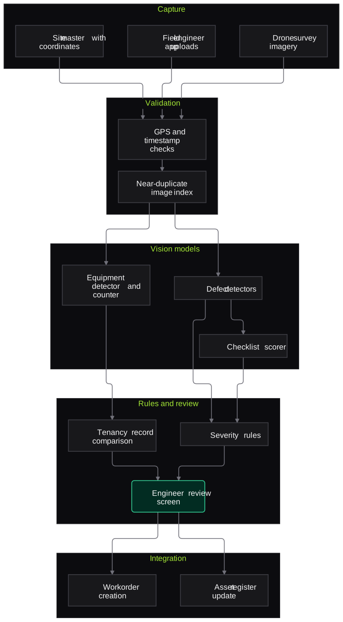
Architecture
- Capture
- Field engineer app uploads
- Drone survey imagery
- Site master with coordinates and tower type
- Validation
- GPS and timestamp checks
- Near-duplicate image index across visits
- Vision models
- Equipment detector and counter
- Defect detectors
- Checklist scorer
- Rules and review
- Tenancy record comparison
- Severity rules
- Engineer review screen
- Integration
- Work order creation in the O&M system
- Asset register update
- Site health dashboards
Inputs and outputs
Inputs
- Field-engineer photo sets per visit
- Drone imagery, as stills or video frames
- Site master with coordinates, tower type and height
- Tenancy and billing records of equipment per tenant
- Inspection and preventive maintenance checklists
- Photos from earlier visits
Outputs
- Photo validity report per visit
- Equipment counts per mount and tenant
- Defect list with severity and annotated photos
- Preventive maintenance checklist score
- Draft work orders and tenancy discrepancy list
Where people stay in control
Engineers review every high-severity or low-confidence finding on the annotated photo, and the O&M lead signs off lower-severity findings in batches before work orders are raised. Tenancy discrepancies go to the commercial team for verification before any billing query reaches a tenant.
Integrations
- Field force or O&M mobile app
- Asset management or ERP such as SAP PM or IBM Maximo
- Drone survey platforms and image storage
- Ticketing or work order system
- GIS for site locations
Guardrails
- No work order closed and no billing changed automatically
- Confidence thresholds set per defect type and reviewed with engineers
- Models evaluated on a held-out set of your own site photos before each update
- People in photos blurred before storage
- Every finding linked to the original, unedited image
Compliance notes
- Drone surveys must follow India's Drone Rules, 2021 for airspace zones and permissions; the pipeline only processes imagery you capture.
- Site photos can capture people nearby; blurring and retention limits are designed to support DPDP Act 2023 data minimisation.
A typical pilot
Duration: 4 weeks
One cluster of sites with recent preventive maintenance photos and a sample of drone surveys, compared with engineer audit outcomes.
Deliverables
- 01Labelled sample from your sites for training and testing
- 02Validation, detection and defect pipeline for the pilot cluster
- 03Engineer review screen with annotated findings
- 04Accuracy report against engineer audits
- 05Roll-out plan and cost estimate
What we measure
- Equipment count accuracy
- Detected counts per mount compared with engineer counts on the same sites.
- Defect precision
- Share of flagged defects that engineers confirmed.
- Invalid photo detection
- Reused or off-site photos caught, compared with audit findings.
- Review time per site
- Engineer time to review a site's findings, compared with full manual photo review.
FAQs
01Can it measure antenna azimuth and tilt?
It can estimate orientation from drone imagery and flag visible deviations from the planned configuration, but it is not a substitute for instrument measurement. Flagged sites go to field teams for verification.
02Do we need drones to use it?
No. Field-engineer photos taken to a consistent checklist support most checks. Drone imagery adds coverage for tall towers and items not visible from the ground.
03How are the models trained for our equipment?
We start with general detection models and fine-tune them on a labelled sample of your own site photos, covering your tower types, mount styles and equipment. The labelled sample also becomes the test set for each model update.
04Can it run in our environment?
Yes. It can run in your cloud account or on on-premise servers with GPUs, and photos never need to leave your environment.
Related use cases
- Energy, Mining & Utilities
Solar Panel Inspection from Drone Images
Turn drone thermal and RGB surveys of solar plants into a checked defect register mapped to block, inverter, string and module, ready for O&M work orders and warranty evidence.
- Energy, Mining & Utilities
Field Technician Voice Reporting
Linemen, fitters and plant technicians speak their job report in Hindi or a regional language, and the system turns it into a structured CMMS entry for supervisor approval.
- Real Estate & Construction
Construction Site Safety Compliance
Use site cameras and safety walk photos to spot missing helmets, unguarded edges, people in crane and hoist zones and poor housekeeping, with each observation verified by the safety officer.

Founded by Akhilesh Mittal. 8 years building a security platform for a New Zealand company. IIT ISM Dhanbad and IMT Ghaziabad. Builds production agentic AI.
Start with one queue or one campaign
Bring a sample of recordings or one call flow. We will scope a pilot on your own calls, in your languages, and measure it against your current process.