Field Survey Photo Verification for Crop Insurance
Check geotagged field survey photos for crop insurance claims for location, timing, crop type, visible damage and reuse, so claim officers spend their time on cases that need judgement.
- Industry:
- Agriculture & Agritech
Who it is for
- Head of Crop Insurance Claims
- Agri Claims Operations Manager
- Survey Agency Project Manager
- Fraud Control Lead, General Insurer
The problem
Crop insurance claims for localised calamities and post-harvest losses depend on field surveys, crop cutting experiments and the photos surveyors upload from the field. In a bad season, thousands of photos arrive within a few weeks, and claim teams cannot check every one for location, timing or reuse.
Photos that do not match the plot
Geotags fall outside the insured survey number, or the photo shows a different crop from the one declared at sowing.
Reused and recycled images
The same photo, or a near-copy, appears across several claims or comes from a previous season.
Timing gaps
Photos taken before the reported event or long after harvest weaken the evidence but are hard to spot manually.
Survey backlog during calamities
After heavy rain, hail or a pest outbreak, claim teams face a spike in surveys with fixed reporting timelines.
What we build
We build a verification layer that checks every survey photo and its metadata before a claim officer opens the file. It compares the photo's geotag with the plot boundary or survey number on record, checks the timestamp against the reported loss event and crop calendar, and confirms the visible crop matches the sowing declaration. A vision model describes visible damage such as lodging, waterlogging or pest attack, without estimating a payable loss. Perceptual hashing finds reused or near-duplicate photos across claims and seasons. Survey forms are read so their details can be compared with the photos. Each claim gets a checklist of passed and failed checks, and failed or uncertain items go to a claim officer.
- Geotag check against plot boundary or survey number coordinates
- Timestamp check against the reported event date and crop calendar
- Crop type recognition compared with the sowing declaration
- Visible damage description such as lodging, waterlogging or pest attack
- Duplicate and near-duplicate photo detection across claims and seasons
- Per-claim evidence checklist for claim officers
How it works
- 01Receive the survey packetPhotos, metadata and survey forms arrive from the surveyor app or survey agency upload, grouped by claim or intimation number.
- 02Check location and timeGeotags and timestamps are compared with the insured plot and the reported loss event.
- 03Check crop and damageThe vision model confirms the crop type and describes visible damage in standard categories.
- 04Check for reuseEach photo is compared with earlier photos across claims and seasons to find copies and near-copies.
- 05Route by resultClaims where all checks pass go forward; failed or uncertain checks go to a claim officer or for re-survey.
- 06Officer decision and recordThe claim officer decides with the checklist and photos in front of them, and the decision and evidence are logged.

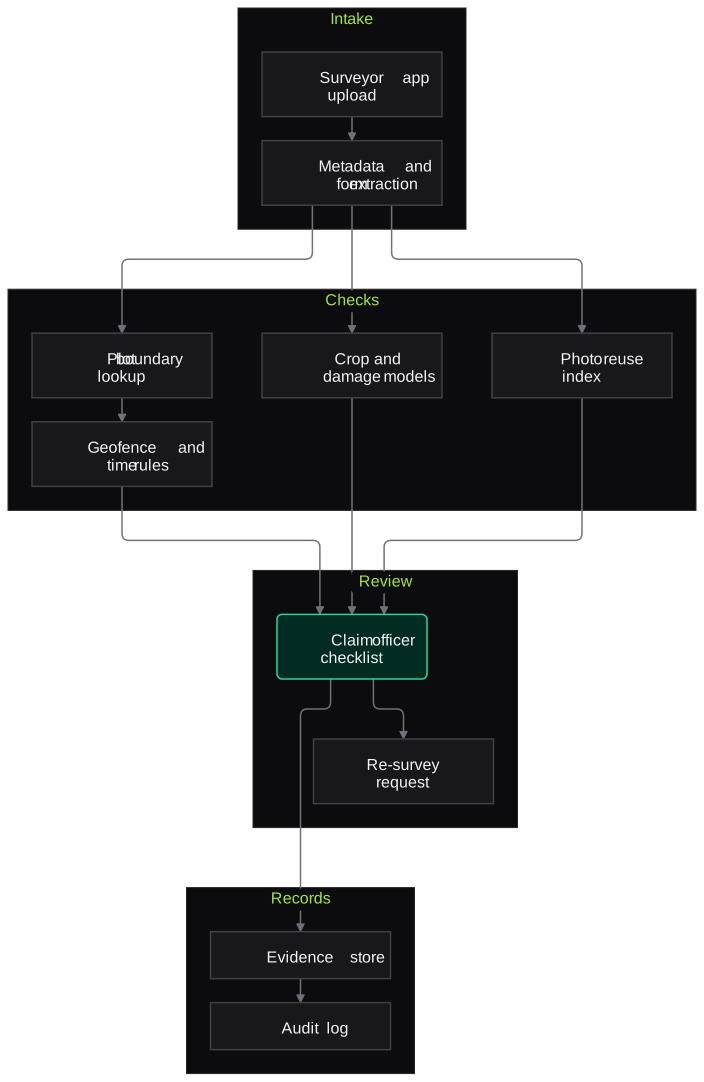
Architecture
- Intake
- Surveyor app or agency upload connector
- EXIF and metadata extraction
- Survey form OCR
- Spatial and time checks
- Plot boundary and survey number lookup
- Geofence and distance check
- Event and crop calendar rules
- Vision
- Crop type classifier
- Damage category detector
- Perceptual hash index for reuse detection
- Review
- Claim officer checklist screen
- Re-survey request workflow
- Records
- Evidence store with original files
- Audit log of checks and decisions
Inputs and outputs
Inputs
- Geotagged survey and crop cutting experiment photos
- Survey forms and claim intimation details
- Insured plot details with survey or khasra numbers
- Sowing declaration and crop calendar
- Reported loss event dates and affected areas
Outputs
- Per-claim verification checklist with pass, fail or uncertain status
- Flags for location, timing, crop mismatch and photo reuse
- Visible damage description per photo
- Re-survey requests
- Audit trail for each claim
Where people stay in control
Claim officers and surveyors decide every claim. The system checks evidence and describes visible damage, but it never estimates payable loss or rejects a claim on its own; failed checks lead to review or re-survey, not automatic denial.
Integrations
- Surveyor mobile app or survey agency portal
- Insurer claims system
- Land record and plot boundary data, where available
- National Crop Insurance Portal data exports, where available
- GIS tools for plot mapping
Guardrails
- No automatic claim rejection from any single check
- GPS drift tolerances agreed with the claims team
- Original files kept unchanged, with checks run on copies
- Farmer identity and location data restricted by role
- Regular sampling of passed claims by a senior claims officer
Compliance notes
- Designed to support the photo, geotag and survey evidence practices described in PMFBY operational guidelines, without replacing the surveyor's assessment.
- Claim records and audit trails help insurers evidence fair claim handling under IRDAI expectations.
A typical pilot
Duration: 4 weeks
Photos from one completed season's surveys in one or two districts, re-checked against decisions already made, before any use on live claims.
Deliverables
- 01Check rules agreed with your claims team
- 02Verification pipeline run on historic survey photos
- 03Claim officer checklist screen
- 04Report comparing flags raised with past decisions
- 05Plan for live use in the next season
What we measure
- Flags confirmed by officers
- Share of flags that claim officers agree are genuine issues on review.
- Duplicate photos found
- Count of reused or near-duplicate photos detected and confirmed by manual check.
- Crop recognition agreement
- Model crop type compared with the sowing declaration and the officer's judgement.
- Officer review time per claim
- Time to review a claim with and without the checklist, measured on a sample.
FAQs
01Can this decide how much crop was lost?
No. It checks whether the photo evidence is consistent and describes visible damage. Loss assessment stays with surveyors, crop cutting experiments and the claim officer.
02What if GPS is inaccurate in the field?
Phone GPS can drift, so the location check uses tolerances agreed with your team and treats small deviations as uncertain rather than failed. Officers see the distance on a map before deciding.
03Does it work with photos from different surveyor apps?
Yes, as long as photos keep their metadata or the app records location and time separately. If metadata has been stripped, the system flags the photo so it can be retaken.
04How is farmer data protected?
Data stays in your cloud or an India region, access is restricted by role, and only the fields needed for verification are processed. Original files are never modified.
Related use cases
- Agriculture & Agritech
Crop Disease Detection from Farmer Photos
Suggest likely diseases, pests and nutrient problems from farmer photos sent on WhatsApp or an app, reply in the farmer's language, and route uncertain or dose questions to an agronomist.
- Agriculture & Agritech
Land Record and KCC Loan Document Extraction
Read Khatauni, 7/12, Jamabandi and other land records plus KCC loan papers, extract holdings and crops, convert local area units, and flag mismatches before a credit officer sanctions.
- Insurance
Motor Claim Damage Assessment from Photos
Detect damaged panels and damage types from guided claim photos, check them against the workshop estimate and pre-inspection images, and give surveyors a structured evidence pack.
- Insurance
Tampered and Fraudulent Document Detection
Score claim documents for signs of editing, fabrication and reuse, explain each signal, and route high-risk files to your investigation team instead of labelling anyone a fraudster.

Founded by Akhilesh Mittal. 8 years building a security platform for a New Zealand company. IIT ISM Dhanbad and IMT Ghaziabad. Builds production agentic AI.
Start with one crop, one district or one document type
Tell us the workflow that costs your field, agronomy or credit team the most time. We will scope a short pilot on your own photos, calls or files.